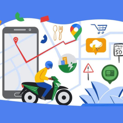
Google Maps has a fascinating story that goes way beyond mere directions. Its roots run deep in the Asia Pacific region, where back in 2004, two Aussies and two Danes in Sydney embarked on a journey that would lead to the creation of the technology underpinning Google Maps. Today, this service boasts more than a billion monthly active users, making it an integral part of our daily lives. So, let’s take a closer look at how Google Maps evolved and the remarkable ways it’s been a game-changer specifically in the Asia Pacific region.
When Google first launched Maps in 2005, the idea was quite simple: to map the world digitally. It was like creating a digital version of a paper map, which might not sound groundbreaking today, but back then, it was unheard of. Google wasn’t even sure if it was possible. However, they set out to prove that it was, one step at a time.
As time went on, Google Maps evolved far beyond its original mission. The driving force behind this evolution was the people who used it daily. They took the everyday experiences of individuals and turned them into innovations.
Here are some ways Google Maps has improved the lives of people in Asia Pacific region:
Inspiring new Google Maps features from the Asia Pacific region
One of the most striking examples of Google Maps’ adaptability and responsiveness to the diverse needs of its users comes from the Asia Pacific region. In many Asian countries, motorbikes are the primary mode of transport. These riders often use unmarked and unpaved roads that are too narrow for cars to navigate. In 2017, Google sent a team to India to work with a community of motorbike riders. Their mission was to enhance the suggested routes on Google Maps, making them more suitable for two-wheelers.
The result was the introduction of the ‘Two-wheeler mode’. It first launched in India and then quickly spread to places where motorbike travel is common, including Indonesia, Malaysia, Hong Kong, Singapore, Taiwan, Thailand, and even as far away as Kenya. This feature revolutionized the way motorbike commuters could navigate their cities, making their journeys safer and more efficient.
Providing emergency help in times of crisis
Google Maps also became a vital tool during times of crisis. When the devastating Tohoku Earthquake struck Japan in 2011, it was the second-largest earthquake ever recorded in the country. This catastrophe triggered a massive tsunami, resulting in power outages and the release of radioactive materials into the surrounding area.
In response, Google’s Crisis Response teams acted swiftly. They created various maps to display critical information, such as power outages, radioactive areas, and the status of open roads. This marked a milestone as it was the first time Japan had used digital tools for crisis response. Google Maps proved that it isn’t just about providing directions; it could be a lifeline during emergencies.
Exploring Asia Pacific region with Street View on Google Maps
Google Maps’ journey of innovation also involved taking users on virtual explorations through its Street View technology. Initially, the idea of creating a 360-degree map of the world might have sounded far-fetched, but Google launched Street View in the U.S. in 2007. It soon made its way to Japan and Australia.

Today, Street View allows people to virtually explore a plethora of locations across the Asia Pacific region, from the awe-inspiring depths of the Great Barrier Reef to the otherworldly landscapes of Uluru-Kata Tjuta National Park. You can even venture inside an active volcano in New Zealand or marvel at the intricate beauty of the temples of Angkor Wat. With the help of local partners, you can also explore the vibrant streets of cities across India.
But Street View isn’t just about virtual tourism. It’s a fundamental component of Google Maps, serving as the bedrock for providing up-to-date information about the world. Thanks to cutting-edge AI technology, Google has been able to introduce new features. ‘Lens in Maps’ helps you discover shops or ATMs along your route, and ‘Immersive View’ provides insights into weather and crowd levels before you visit a place. It’s about making your journey not just efficient but enjoyable.
Google Maps to the rescue during a mask shortage
The COVID-19 pandemic posed a unique challenge for Taiwan in early 2020. After the first case appeared on January 21, everyone was scrambling to buy face masks. The problem was that Taiwan could only produce 1.88 million masks per day. Even when the government released 44 million emergency masks, they were sold out almost immediately as soon as they hit the supermarket shelves. People flocked to multiple stores every day to secure supplies, putting themselves at risk.

In the midst of this crisis, while at the supermarket, Howard Wu noticed the chaos. People rushed to the counter to line up and buy masks, but as soon as the clerk announced that masks had run out, the line vanished, only to reappear a few minutes later when newcomers arrived at the store. The solution was clear: people needed to know which stores had masks in stock to avoid wasting time and risking infection.
Using the Google Maps interface as a foundation, Howard Wu and other Taiwanese Google Developer Groups developers created a color-coded map. This map showed users which stores had masks (marked in green) and which had sold out (marked in red). Users could also see the exact quantity of adult and child masks in stock at each store. What made this effort even more remarkable was that all this data was manually crowdsourced by users, turning it into a heartwarming community initiative.
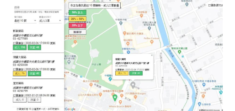
The map gained the attention of Taiwan’s digital minister, who met with the country’s premier to discuss how the government could use this map to be even more helpful. The government granted permission to publicize their National Health Insurance system’s database. This allowed for real-time updates of pharmacy product inventory, making the information more accurate and up-to-date than ever before.
This success story in Taiwan illustrates how Google Maps, when adapted to local needs, can be a powerful tool in times of crisis, helping communities come together and overcome challenges.
Local guides making inclusivity a priority
Penny Christie, an artist based in Sydney, Australia, is part of the Local Guides program on Google Maps. This program is comprised of millions of individuals worldwide who share their local experiences to help others make informed decisions about where to go.
Penny is passionate about ensuring that everyone has the right to navigate the world freely and safely. Her focus as a Local Guide is on making places more LGBTQI+ and accessibility-friendly, and ideally, both. She’s spent years looking for and highlighting accessibility-friendly features, whether it’s in a restaurant, a store, or a park. Penny’s reviews are not your typical recommendations; they contain valuable information about ramps, wheelchair lifts, braille signage, and hearing loop sound systems for those with hearing aids. She takes photos and videos of a place’s layout, especially useful for individuals sensitive to loud environments. She also checks for accessible restrooms and whether they have baby-changing facilities.
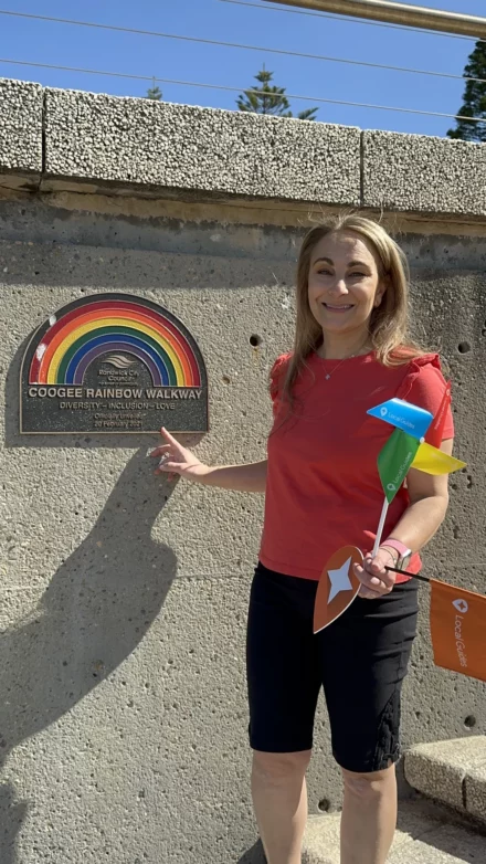
Penny’s contributions on Google Maps make it easier for people to assess a place’s accessibility before they visit, ensuring that everyone, regardless of their needs, can navigate and enjoy the world with ease.
Putting a Woodcarving village on the Google Maps
Wasan Dechakan, a woodcarver hailing from Baan Tawai, a quaint village in northern Thailand, used Google Business Profiles on Search and Maps to bring attention and visitors to his hometown. The village, like many others, thrives on its local knowledge and artisanal traditions, particularly woodcarving. Over the years, the village faced the challenge of rising competition, as it was not located in the city center, making it difficult to attract tourists’ attention.
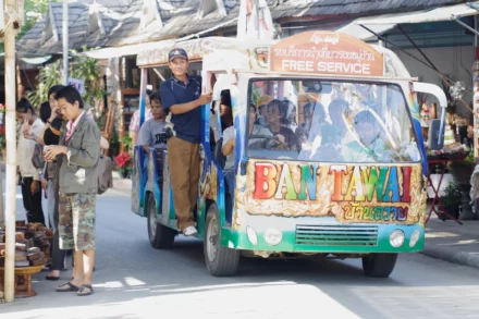
Wasan recognized the power of Google Maps and, in 2004, put his community on the digital map using Business Profiles. He showcased the types of beautiful handicrafts they created. The impact was immediate; Wasan began receiving inquiries and calls from customers and tourists interested in their products. People started visiting Baan Tawai in groups, which brought in a significant number of visitors.
In the spirit of community, Wasan shared his knowledge with other villagers, teaching them how to create Business Profiles for their respective businesses. As a result, the village collectively found a place on the global map. They even formed relationships with customers from Australia, Europe, and England, who now source their products from Baan Tawai. The village became a hub for tourists from all over the world, preserving and sharing their rich cultural heritage.
Solving India’s street name conundrum
The story of Google Maps in India is unique. When the service first launched in the country in 2008, Google quickly realized that they had a problem. The foundation of Google Maps relied on street names, which were severely lacking or inconsistent in India. Many streets had multiple names, were unofficial, or were known by entirely different names on the ground. In the words of Elizabeth Laraki, Google Maps’ UX Design Lead from 2007 to 2009, the directions became ‘pretty much useless’ in India.
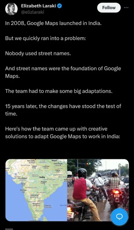
However, Google Maps was not to be deterred. They recognized that in many parts of the world, including India, landmarks were a crucial navigational tool. An innovative shift in strategy followed, inspired by the unique navigation methods of the Indian population.
Through nimble, on-the-ground field research, the Google Maps team sought to understand how Indians used landmarks for navigation. They discovered that landmarks played key roles in orientation (e.g., ‘Head towards the water’), turn descriptions (e.g., ‘Turn past the shopping center’), confirming if they were on the right path (e.g., ‘You will see a petrol pump on the right’), and error correction (e.g., ‘You will see [landmark] if you have gone too far’).
Google Maps adapted to the needs of the Indian population by incorporating landmarks such as parks, monuments, shopping centers, landmark buildings, and petrol pumps into their navigation system. These changes transformed Google Maps into the dominant navigation product for India, proving that technology could adapt to local conditions and still be a game-changer.
Conclusion
These stories from the Asia Pacific region are just a glimpse of the impact of Google Maps on our lives. While we use Google Maps every day to navigate the world around us, we often underestimate the profound ways in which it has enriched societies and communities across the globe.
Google Maps is a testament to how technology, driven by innovation and a commitment to making a meaningful difference, can navigate our world and improve lives one direction at a time.
Inline image sources: Google blog

Karanjot Sidhu
1024 Posts
A computer science engineer who loves tech and won't stop talking about it. Here at Piunikaweb, I mostly cover Google Pixel deals and how-tos, though you may find me covering Pixel news as well sometimes. Apart from being a nerd, i love gaming and watching movies in my free time.
Next article View Article